Ann Arbor, Michigan
1926 Map
Ann Arbor, Michigan
1926 Map


Click here for the interactive 1866 Ann Arbor Map
Click here for list of buildings on the 1866 Ann Arbor Map
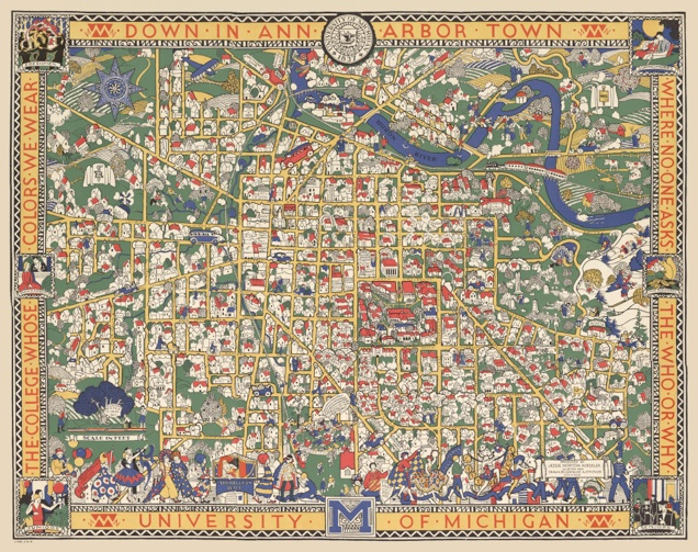
Mid-1920s City Map Has Been Reprinted By U of M Alumnae
In 1926 a very colorful, 5 color map of Ann Arbor town was produced by Jessie Horton Kessler, a 1901 graduate of the University, from a drawing made by Gertrude A. Strickler of Chicago. Covering the area roughly bounded by Berkshire Road and what’s now the North Campus of the U of M, Cedar Bend Drive on the north, Revenna Boulevard on the west, and Stadium Boulevard on the south, the map is actually a redu, a type of drawing on a plane surface in which the topography buildings and other physical features are depicted in a three-dimensional technique.
“The map is a masterpiece of the Art Deco style,” commented Mrs. Ruth Williams, chairperson of the U of M Alumnae group who produced the reprint from an original owned by Sam Breck, Jr., of Ann Arbor. But there’s a good deal of mystery about the map,” said Mrs. Williams. “No one is really sure of the purpose for which it was produced, although we have had some people venture that it was sold to raise money to help build the Michigan League. We’d like to know more about the map from anyone who knows its history.”
U of M. graduates and Ann Arbor citizens as well will find a wealth of memories in the map, which shows long gone eating places, student haunts, notable houses and buildings, and such spots as Joe Parker’s and the Orient. Heavily embellished with cartoon-like caricatures, the map is a constant source of discovery of the Ann Arbor of fifty years ago.
(Ann Arbor Scene Magazine (Summer 1976, v.4, no.2), p 35)
A New Map of Ann Arbor
As her share toward the League campaign fund, Mrs. Karl K. Koessler, ’01 who in her University days was Jessie Horton, has contributed a most interesting, not to say fascinating map of Ann Arbor, a reproduction of which appears above. These maps which are being sold for the benefit of the League at $1.50 each, are intriguing, gay in color, with Maize and Blue, of course, predominating, and are calculated to form a rich wall decoration for any home besides giving anyone interested a pleasant half hour locating well loved spots.
Thus all the fraternity houses ar shown, the Campus buildings, “Joe’s” old place of business, as well as the Orient,” a football game is under way on Ferry Field. If lone looks close one can find a cross-country many taking his daily constitutional, while busses indicate the main road to Detroit and Jackson. All in all there is very little the artist, Miss Gertrude A. Strickler of Chicago, left out. The map is really composed of thousands of details of which the reproduction gives only a faint idea.
(The Michigan Alumnus, page 262 December 25, 1926)